
Business & Startups

NATO Allies Seek Commercial Satellite Imagery for Early Threat Detection

Date: September 22, 2026

European NATO allies are increasingly turning to commercial satellite imagery to enhance their ability to detect security threats at an earlier stage, according to the CEO of Planet Labs.

Shift in European Defense Strategy

Will Marshall, the Chief Executive Officer of Planet Labs, indicated that there is a growing interest among European nations in accessing commercial space-based data. This shift is driven by the evolving security landscape in Europe, where traditional intelligence methods are being supplemented by real-time commercial data streams.
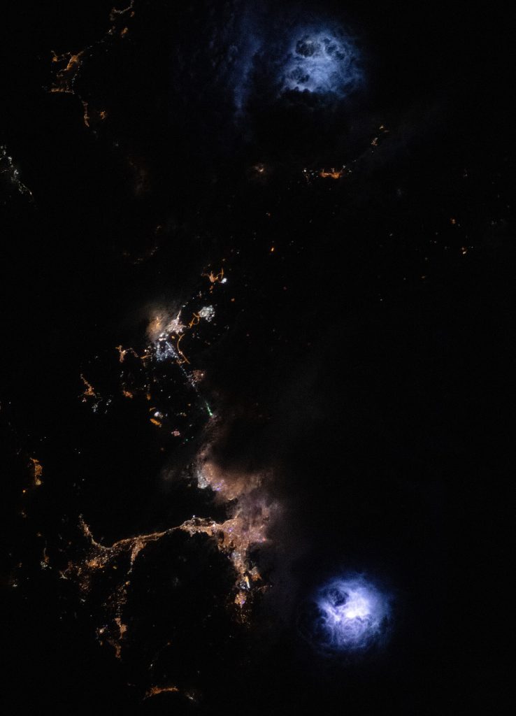
An astronaut aboard the International Space Station took this photograph of a thunderstorm at night over western Türkiye. The image highlights two distinct lightning flash areas, one southeast of the city of İzmir and the other north of Aliağa. Using a camera’s time-lapse function and the proper shutter speed, astronauts can capture photos of the bright flashes amidst the clouds while simultaneously documenting nearby nighttime lights from cities and highways. The image’s high spatial resolution, combined with the temporary illumination of the lightning flash, reveal the cloud textures from above—a unique attribute of astronaut photography of Earth at night. The dark and light patches within the cumulonimbus clouds expose the strong updrafts present in storm cells. In addition to lightning, the image captures the municipal lights from the cities of İzmir, Yelki, and Aliağa bordering the Gulf of İzmir. Storm clouds obscure some of the urban lights toward the eastern side of the gulf. Remote sensing of nighttime storms has been the focus of several scientific projects aboard the space station. Astronaut imagery has extended our understanding of atmospheric phenomena associated with lightning, including sprites and blue jets. In addition to crew photography of Earth, robotic sensors aboard the station, such as the European Space Agency’s Atmosphere-Space Interactions Monitor (ASIM), observe these atmospheric phenomena and convective storms. Scientists have also used the data collected by the Lightning Imaging Sensor (LIS) to map lightning strikes and gain insight into lightning dynamics across the planet during both daytime and nighttime storms.
This image or video was catalogued by Goddard Space Flight Center of the United States National Aeronautics and Space Administration (NASA) under Photo ID: 153092 and Alternate ID: iss070e021172. · Wikimedia Commons · Public domain

The Influence of the Ukraine Conflict

Marshall specifically cited the ongoing conflict in Ukraine as a primary catalyst for this change in perspective. European countries are observing how Ukraine has utilized commercial satellite imagery to support its military operations and strategic planning. This visibility into the practical application of such technology has prompted NATO members to reassess their own reliance on and access to these commercial assets.

The use of commercial satellites in modern warfare has demonstrated the value of high-frequency, high-resolution imagery in tracking troop movements, assessing damage, and identifying emerging threats. As European defense budgets and strategies adapt to the current geopolitical reality, the integration of commercial space data is becoming a priority for many allied nations.

Commercial Space and National Security

For decades, satellite imagery was largely the domain of state-owned space agencies and military programs. However, the rise of the commercial space sector has democratized access to this critical data. Companies like Planet Labs provide imagery that can be acquired more quickly and often at a lower cost than traditional government contracts, allowing for more agile response times.
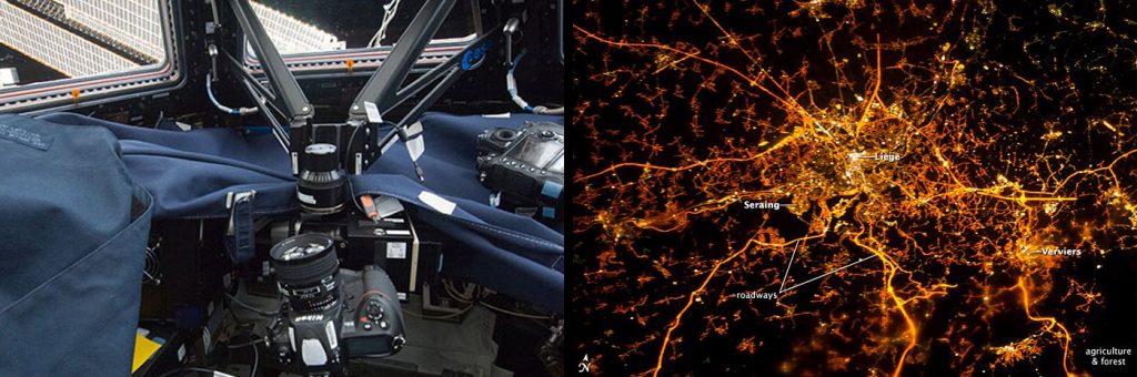
To read more go to: www.nasa.gov/mission_pages/station/research/news/nightpod... There is a reason the phrase "shooting in the dark" refers to things that are difficult to do -- and night photography is no exception. To account for low-light image scenarios, a photographer needs a steady tripod, but aboard the International Space Station, a traditional tripod isn't going to cut it. Thankfully, the European Space Agency, or ESA, developed NightPod for the crew's cameras. This astronaut photograph of Liège, Belgium, at night was taken using the NightPod camera mount aboard the space station. The mechanism allows astronauts to capture images of the Earth at night with greater clarity and control than previously possible from orbit. "The challenges of low-light photography from orbit -- for example, the likelihood of blurry images because of the ground motion -- have always frustrated astronauts," said Cynthia Evans, International Space Station associate program scientist for Earth Observations. "Over the years, astronauts have experimented with different solutions, including high-speed films and manual tracking to compensate for the ground motion. The NightPod camera mount allows the crew to successfully track the Earth using low-light camera settings." NightPod incorporates a nodding mechanism, which is an electro-mechanical mount system for digital cameras designed to compensate for the motion of the station relative to the Earth. This high-tech, motorized tripod can compensate for the more than 17,000 mph (27,000 kph) speed of the station and the motion of the Earth below—no easy feat! The crew enters the station's orbit and attitude into NightPod, enabling the instrument to automatically track a specific location on the ground and keep the target in frame for optimal focus. Since the system can be set to run automated for up to six hours, the crew can literally take pictures in their sleep. To get an idea of just how clear images using NightPod are, look at how detailed the brightly lit core of the Liège urban area appears. It lies at the center of a network of roadways -- traceable by continuous orange lighting extending out into the rural and relatively dark Belgian countryside. For a sense of scale, the distance from image left to right is approximately 43 miles (70 kilometers). The region to the southeast of Verviers includes agricultural fields and forest; hence, it appears almost uniformly dark at night. The image of Liège was acquired on Dec. 8, 2012, with a Nikon D3S digital camera using a 180 millimeter lens and the NightPod, and is provided by CEO investigators and the Image Science and Analysis Laboratory at Johnson Space Center. The image was taken by the Expedition 34 crew. It was cropped and enhanced to improve contrast, and lens artifacts were removed. Installation of NightPod was completed on Feb. 24, 2012, by astronaut André Kuipers, and some of the earliest images appear in this ESA story. The primary goal of NightPod is to take high-resolution, long-exposure digital imagery of the planet from the station's Cupola, particularly cities at night. Other scenarios of interest include evening observations of brush fires, visual analysis of maritime and road traffic, volcano activity, urban pollution, squid fishing and day/night transitions. "Nighttime imagery from orbit provides an instant understanding about humanity's footprint on the Earth's surface," Evans said. While the official NightPod mission is done, the mechanism remains on station for astronauts to use as part of the Crew Earth Observations, or CEO, investigation. For CEO, the astronauts photograph natural and human-made events on Earth from the orbiting lab. The images record the ground's surface changes over time, atmospheric phenomena like aurora and polar mesospheric clouds, and dynamic happenings such as storms, floods, fires and volcanic eruptions. Together with automated remote sensing systems on the space station, handheld camera imagery provides researchers with data to understand the planet from an orbital perspective. The International Space Station Program supports the imaging laboratory as part of the U.S. National Lab to help astronauts take pictures of Earth that will be of the greatest value to scientists and the public, and to make those photographs freely available on the Internet. Additional images taken by astronauts and cosmonauts can be viewed at the NASA/JSC Gateway to Astronaut Photography of Earth. Jessica Nimon/William Stefanov International Space Station Program Science Office NASA image use policy. NASA Goddard Space Flight Center enables NASA’s mission through four scientific endeavors: Earth Science, Heliophysics, Solar System Exploration, and Astrophysics. Goddard plays a leading role in NASA’s accomplishments by contributing compelling scientific knowledge to advance the Agency’s mission. Follow us on Twitter Like us on Facebook Find us on Instagram
NightPod Images Bring Earth to Light From Space Station · Wikimedia Commons · Public domain

As NATO allies seek to spot threats earlier, the speed and accessibility of commercial data become significant advantages. The ability to monitor vast areas of territory continuously allows for a more proactive rather than reactive defense posture. This trend suggests a broader integration of private sector capabilities into national security frameworks across the alliance.

Implications for the Defense Industry

The increased demand from European NATO members is likely to have significant implications for the commercial space industry. Defense contractors and space technology firms may see a surge in contracts and partnerships as governments seek to secure reliable access to these data streams. This development underscores the blurring lines between commercial technology and military application, a trend that has accelerated in recent years.

While the specific details of these new acquisitions or partnerships have not been fully disclosed, the CEO’s comments highlight a strategic pivot. European allies are no longer just consumers of intelligence but are actively seeking to diversify their sources of situational awareness, with commercial satellite imagery playing a central role in this new approach.

Conclusion

The move by NATO allies in Europe to prioritize commercial satellite imagery reflects a broader adaptation to modern warfare and security challenges. By learning from the experiences of Ukraine and leveraging the capabilities of the commercial space sector, these nations aim to improve their early warning systems and overall strategic resilience. This shift marks a significant development in the intersection of technology, business, and national defense.

Sources

More like this